Certified engineers

SIMULATIONS, DIGITAL LAND AND GROUNDWATER MODELLING, GEOGRAPHIC INFORMATION SYSTEM (GIS)

Highly-specialised ecoinformatics services

Our GIS technical department develops transparent, interdisciplinary solutions for complex environmental issues using highly-specialised computers for geostatistics, geotechnical measurement systems and geographic information systems. Our application focus is on simulations, digital land and groundwater modelling and geographic information systems (GIS).


Digitalen Gelände- und Grundwassermodellierung mittels hochspezialisierter Software

Digital land and groundwater modelling using highly-specialised software


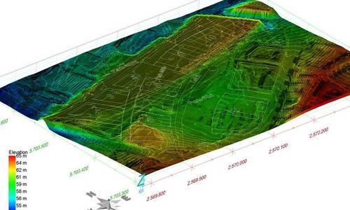
Field of application: environmental informatics

Environmental informatics makes it possible to calculate and present the effects of construction activities, pollution inputs and temperature changes on the subsoil. Precise cost estimates and increased data transparency provide important support in decision-making with regard to official approval procedures and the commercial performance of construction activities.

GIS: OUR SERVICES

Our environmental computing services include the following:

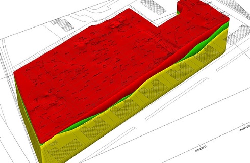
  • Geostatistical calculations and geotechnical monitoring in foundations, such as structural analysis around shoring, settling, etc.
  • Groundwater models and models of the spread of pollutants in groundwater
  • Simulation of geothermal systems, such as soil probes, exchanger fields and well systems, as well as groundwater retention with construction trenches and in sewer construction
  • GIS for gathering, managing and assessing a great deal of environmental information for the economic and ecological optimisation of terrain usage and remediation
  • Creation of technical drawings and blueprints, as well as the presentation of geotechnical investigations (drilling, dynamic probing, etc.)


Geostatistics and visualisation

Massenermittlung zur Kostenplanung

Massenermittlung mit 3D Spezialsoftware

Computer models of geological layers or contamination are created using geostatic methods in order to calculate the volumes of structurally separable soil qualities or the spread of pollutants in the soil, for example. This enables the determination of very precise volumes early on and thus determine costs for safety, construction or disposal activities.


Digital 3D terrain modelling and volume determination

Terrain modelling generates a digital picture of morphological and geological conditions using a large amount of three-dimensional point data.

It is used for the presentation of terrain surfaces, trenching, filling and geological layers in order to achieve a vivid visualisation and as exact as possible a volume determination for planning construction trenches, stockpiles and landfills.

In this way, for example, the volumes of soil qualities which can be structurally separated can be determined in a more precise way, ensuring economically optimal disposal.

Groundwater modelling

Umweltinformatik Idealisierte Nachbildung realer hydrogeologischer Phänomene um Prognosen zur Grundwassersituation zu erstellen

Groundwater modelling

Groundwater modelling is about forming an idealised image of real hydrogeological phenomena in order to generate forecasts of the groundwater situation.


Geographic information systems (GIS)

For all technical areas, the capture, management and analysis of varied spatial and environmental data is carried out on a project-specific basis using a Geographic Information System (GIS).

Umweltinformatik Darstellung der Raum- und Umweltdaten in unserem GIS

Information presentation GIS

All relevant data from a location are combined into one system in the form of a “digital library,” and are presented in images with spatial relationships. Consequently they  are easy to follow.


CAD- / Construction drawings

Umweltinformatik Darstellung CAD Zeichnung

CAD construction drawing

Designs  are drafted which are produced within the scope of analyses and planning services.


DO YOU HAVE QUESTIONS REGARDING GIS?

Call us at:

+49 228 – 97458293


KÜHN Geoconsulting® GmbH is an independent consulting firm that has been active in the fields of subsoil consulting and remediation of contaminated sites for more than 50 years.


With an engineering quota of 74 percent and a workforce of over 50 long-standing employees, we are in a position to serve even major projects reliably, on time and to the highest quality standards.


With the experience from more than 22,500 orders, from single-family homes to high-rise office buildings, our employees develop professional, customer- and practice-oriented solutions.


Certifications and further training are an integral part of our corporate culture, so that you always receive the best state-of-the-art solutions from us.


Companies for which we have already completed projects and orders and who place their trust in us are HochTief, Deutsche Leasing, Vodafon or the city of Cologne. This is only a small selection. Feel free to ask us for further references.

Geoconsulting

Geoconsulting